PART I
 Latitude/Longitude map A
Latitude:
Ireland is located at 53° N, 8°W. Relatively, it is on the west side of the continent Europe. See latitude/longitude map A to the right. Because the country is located a great distance from the equator, weather conditions are cool and changeable. Compared to other locations of the same latitude, Ireland experiences a rather unique climate, explained in a moment.
Ireland is located at 53° N, 8°W. Relatively, it is on the west side of the continent Europe. See latitude/longitude map A to the right. Because the country is located a great distance from the equator, weather conditions are cool and changeable. Compared to other locations of the same latitude, Ireland experiences a rather unique climate, explained in a moment.
 Elevation map B
Elevation:
Given the country's range of geographic features, which include hills, mountains, and cliffs, elevation in Ireland varies. The highest point is 1,041 metres above sea level, located on Carrauntoohil -- a mountain peak. Inversely, the lowest point is -3 metres below sea level, in North Slab -- an area of mudflats. See elevation map B to the left.
Given the country's range of geographic features, which include hills, mountains, and cliffs, elevation in Ireland varies. The highest point is 1,041 metres above sea level, located on Carrauntoohil -- a mountain peak. Inversely, the lowest point is -3 metres below sea level, in North Slab -- an area of mudflats. See elevation map B to the left.
 Climograph C. Click for explanation.
Annual Temperatures & Precipitation:
Based on these factors, Ireland's climate can be described as temperate oceanic, or Cfb using the Köppen classification system. Much of the following information can be interpreted from climograph C to the right: The country experiences relatively warm summers and mild winters, without temperature extremes. The hottest month is June, with mean temperatures around 15°C. The coldest month is January, averaging 4°C. This is quite warm compared to other locations of the same latitude. Why? Because of it’s proximity to the Atlantic Ocean (as an island), Ireland's climate is modified by the warm North Atlantic Drift all year. See ocean current map D below. As a result, conditions in Ireland are warm and moist. Back to the climate graph, Ireland receives abundant precipitation year round, primarily in the form of rainfall. The summer and autumn months are marginally wetter, peaking around 75 millimetres. The winter and spring seasons as a whole sustain less rainfall, the driest month being April with about 45 millimetres.
Based on these factors, Ireland's climate can be described as temperate oceanic, or Cfb using the Köppen classification system. Much of the following information can be interpreted from climograph C to the right: The country experiences relatively warm summers and mild winters, without temperature extremes. The hottest month is June, with mean temperatures around 15°C. The coldest month is January, averaging 4°C. This is quite warm compared to other locations of the same latitude. Why? Because of it’s proximity to the Atlantic Ocean (as an island), Ireland's climate is modified by the warm North Atlantic Drift all year. See ocean current map D below. As a result, conditions in Ireland are warm and moist. Back to the climate graph, Ireland receives abundant precipitation year round, primarily in the form of rainfall. The summer and autumn months are marginally wetter, peaking around 75 millimetres. The winter and spring seasons as a whole sustain less rainfall, the driest month being April with about 45 millimetres.
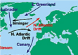
Ocean Current map D. See Ireland to the Southeast of the red North Atlantic Drift indicator.
|
